Land for family house, according to valid Land use plan area
Sale
Land
1 980 m²
Total Area
Description
Land for family house, according to valid Land use plan area BI, individual housing area.
Access by local road.
Detailed information, prices, engineering networks, Land use plan, cadastre and other we will send via email or you can search 'putyrky', it's the first link - Sale of land Roznov pod Radhostem where everything is detailedly described and drawn out.
Parcels 2666/11, Cadastral district Roznov pod Radhostem. Area as per image from Land Register 1980 m². Considering its size there might be an idea about dividing the plot among investors into several parts.
Electricity and sewage connections on the property.
The parcel is located within Beskids Protected landscape area Zone III. Three hundred meters away from border of Zone I. The last place in closure where construction is possible.
Land marked with red boundary line on photographs
School, kindergarten, doctor office, supermarkets health center stadium all just few minutes drive bus stop minute walk bicycle paths and organic farm minute walk
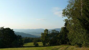
Beskids hills meadows peacefulness All photos taken around the property up to four minutes walk distance
Access by local road.
Detailed information, prices, engineering networks, Land use plan, cadastre and other we will send via email or you can search 'putyrky', it's the first link - Sale of land Roznov pod Radhostem where everything is detailedly described and drawn out.
Parcels 2666/11, Cadastral district Roznov pod Radhostem. Area as per image from Land Register 1980 m². Considering its size there might be an idea about dividing the plot among investors into several parts.
Electricity and sewage connections on the property.
The parcel is located within Beskids Protected landscape area Zone III. Three hundred meters away from border of Zone I. The last place in closure where construction is possible.
Land marked with red boundary line on photographs
School, kindergarten, doctor office, supermarkets health center stadium all just few minutes drive bus stop minute walk bicycle paths and organic farm minute walk
Beskids hills meadows peacefulness All photos taken around the property up to four minutes walk distance
Details
- Location: Vsetín, 756 61
- Created: 5 May 2026
Scan to open online: